
Meta Description:
Complete Drainage Class 9 notes, summary, MCQs, keywords, and important questions. Simple NCERT Geography revision guide for exams and quick learning.
Introduction of the Chapter
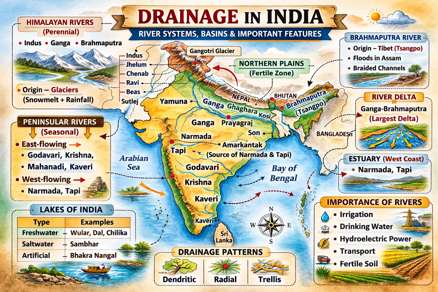
The chapter Drainage in Class 9 Geography explains the river systems of India and their importance in shaping the country’s physical and economic landscape. A drainage system refers to the network formed by rivers and their tributaries in a particular area. India has a rich and complex drainage pattern due to its varied relief features and climatic conditions.
Understanding Drainage is essential because rivers are the lifelines of civilizations. They provide water for irrigation, drinking, transportation, and power generation. The chapter Drainage also highlights the differences between Himalayan rivers and Peninsular rivers and explains the major river systems of India.
The study of Drainage helps students understand floods, river pollution, water management, and the importance of conserving rivers. Questions from Drainage frequently appear in school and competitive examinations.
Short Notes (Bullet Points)
- Drainage refers to the river system of an area.
- A drainage basin is the area drained by a river and its tributaries.
- India’s drainage is divided into Himalayan and Peninsular river systems.
- Himalayan rivers are perennial (flow throughout the year).
- Peninsular rivers are mostly seasonal.
- Major Himalayan rivers: Indus, Ganga, Brahmaputra.
- Major Peninsular rivers: Godavari, Krishna, Kaveri, Mahanadi, Narmada, Tapi.
- Most rivers of India flow into the Bay of Bengal.
- Narmada and Tapi flow into the Arabian Sea.
- Lakes are important sources of freshwater.
- Rivers are important for agriculture, transport, and hydroelectric power.
Detailed Summary of Drainage (900–1200 Words)
The chapter Drainage deals with the river systems of India and their significance. The term drainage describes the river system of an area, including the main river and its tributaries. India’s drainage pattern is influenced by its relief, geological structure, and climate.
What is Drainage?
Drainage refers to the system through which river water flows in a region. The area drained by a river and its tributaries is known as the drainage basin. Each river has its own drainage basin, separated from others by a water divide. The Drainage pattern of India is broadly divided into two major river systems: the Himalayan rivers and the Peninsular rivers.
Himalayan Drainage System
The Himalayan rivers are perennial rivers because they are fed by both snowmelt and rainfall. These rivers have large basins and long courses. The three major Himalayan river systems discussed in Drainage are:
- The Indus River System
- The Ganga River System
- The Brahmaputra River System
The Indus River System
The Indus River rises in Tibet near Lake Mansarovar and flows through India into Pakistan. In India, its main tributaries include the Jhelum, Chenab, Ravi, Beas, and Sutlej.
Features:
- One of the longest rivers in the world
- Forms deep gorges in the Himalayas
- Important for irrigation
The Indus drainage system forms an important part of the Drainage pattern of north-western India.
The Ganga River System
The Ganga is the most important river in India. It originates from the Gangotri Glacier in Uttarakhand, where it is known as the Bhagirathi. After being joined by the Alaknanda at Devprayag, it is called the Ganga.
Important Tributaries:
- Yamuna
- Ghaghara
- Gandak
- Kosi
- Son
The Ganga forms one of the largest and most fertile river basins in the world. The Ganga plain is densely populated because of fertile alluvial soil and abundant water.
The Drainage pattern of the Ganga system plays a crucial role in agriculture and settlement.
The Brahmaputra River System
The Brahmaputra originates in Tibet as the Tsangpo. It enters India through Arunachal Pradesh and flows through Assam before entering Bangladesh.
Key Features:
- Forms braided channels
- Causes frequent floods in Assam
- Carries huge sediment load
The Brahmaputra system is an important component of India’s Drainage network in the northeast.
Peninsular Drainage System
The Peninsular rivers are older and mostly seasonal because they depend mainly on rainfall. Their valleys are broader and shallower compared to Himalayan rivers.
Major Peninsular rivers include:
- Godavari
- Krishna
- Kaveri
- Mahanadi
- Narmada
- Tapi
East-Flowing Rivers
Most Peninsular rivers flow eastwards into the Bay of Bengal. These rivers form large deltas.
Major east-flowing rivers:
- Godavari (largest Peninsular river)
- Krishna
- Mahanadi
- Kaveri
These rivers are very important in the Drainage system for irrigation and delta formation.
West-Flowing Rivers
Only a few Peninsular rivers flow westwards into the Arabian Sea. These rivers form estuaries instead of deltas.
Main west-flowing rivers:
- Narmada
- Tapi
They flow through rift valleys and have shorter courses.
Lakes of India
Lakes are an important part of the Drainage system. They help regulate river flow, support biodiversity, and provide water for various uses.
Types of Lakes:
- Freshwater lakes (e.g., Wular Lake)
- Saltwater lakes (e.g., Sambhar Lake)
- Artificial lakes (reservoirs)
Lakes also help in flood control and groundwater recharge.
Role of Rivers in the Economy
The chapter Drainage emphasizes the economic importance of rivers.
Uses of rivers:
- Irrigation
- Drinking water
- Hydroelectric power
- Navigation
- Fishing
- Fertile soil deposition
However, rivers today face serious problems such as pollution, overuse, and dam construction. River conservation is essential for sustainable development.
Flowchart / Mind Map (Text-Based)
Drainage
→ Meaning of Drainage
→ Drainage Basin & Water Divide
→ Himalayan Rivers
→ Indus
→ Ganga
→ Brahmaputra
→ Peninsular Rivers
→ East-flowing
→ West-flowing
→ Lakes of India
→ Importance of Rivers
→ River Conservation
Important Keywords with Meanings
- Drainage: River system of an area
- Drainage Basin: Area drained by a river
- Water Divide: Boundary between two river basins
- Perennial River: River that flows throughout the year
- Tributary: Smaller river joining a main river
- Delta: Triangular river mouth deposit
- Estuary: Funnel-shaped river mouth
- Meander: Bends in a river
- Braided Channel: River split into many channels
- Distributary: Branch of a river flowing away from main stream
Important Questions & Answers
Short Answer Questions
Q1. What is meant by drainage?
Answer: Drainage refers to the river system of an area, including the main river and its tributaries.
Q2. Why are Himalayan rivers perennial?
Answer: Because they are fed by both snowmelt and rainfall throughout the year.
Long Answer Questions
Q1. Differentiate between Himalayan rivers and Peninsular rivers.
Answer:
Himalayan rivers are perennial because they originate from glaciers and receive rainfall, whereas Peninsular rivers are mostly seasonal and depend mainly on monsoon rains. Himalayan rivers have long courses, deep valleys, and form large deltas. In contrast, Peninsular rivers are older, flow through shallow valleys, and have shorter courses. Himalayan rivers often cause floods due to heavy sediment load, while Peninsular rivers have more stable flow patterns.
Q2. Describe the Ganga river system in detail.
Answer:
The Ganga river system is the most important drainage system in India. It originates from the Gangotri Glacier as the Bhagirathi and becomes the Ganga after meeting the Alaknanda at Devprayag. It flows through Uttarakhand, Uttar Pradesh, Bihar, and West Bengal before entering Bangladesh. Major tributaries include Yamuna, Ghaghara, Gandak, and Kosi. The river forms a vast and fertile plain that supports dense population and intensive agriculture. The Ganga is also culturally and economically significant for India.
20 MCQs with Answers
- Drainage means:
a) Rainfall
b) River system
c) Groundwater
d) Soil erosion
Answer: b - Himalayan rivers are:
Answer: Perennial - The largest Peninsular river is:
Answer: Godavari - Narmada flows into:
Answer: Arabian Sea - The Ganga originates from:
Answer: Gangotri Glacier - A tributary is:
Answer: Smaller river joining main river - The Indus rises near:
Answer: Lake Mansarovar - Most Indian rivers flow into:
Answer: Bay of Bengal - Lakes help in:
Answer: Regulating river flow - Tapi river flows west because of:
Answer: Rift valley - Brahmaputra is known as Tsangpo in:
Answer: Tibet - Yamuna is a tributary of:
Answer: Ganga - Estuaries are common on:
Answer: Western coast - The drainage basin is separated by:
Answer: Water divide - Which river causes floods in Assam?
Answer: Brahmaputra - Peninsular rivers are mostly:
Answer: Seasonal - Sambhar Lake is:
Answer: Saltwater lake - Bhagirathi and Alaknanda meet at:
Answer: Devprayag - Which river forms the largest delta?
Answer: Ganga-Brahmaputra - Rivers are important for:
Answer: Irrigation
Exam Tips / Value-Based Questions
Exam Tips:
- Learn differences between Himalayan and Peninsular rivers.
- Practice map work of major rivers.
- Remember which rivers flow east and west.
- Focus on tributaries of the Ganga.
Value-Based Question:
Why is it important to prevent river pollution?
Sample Answer:
Preventing river pollution is important to protect drinking water sources, aquatic life, agriculture, and human health. Clean rivers ensure sustainable development.
Conclusion
The chapter Drainage provides a clear understanding of India’s river systems and their importance. From the mighty Himalayan rivers to the seasonal Peninsular rivers, the Drainage network supports agriculture, industry, and human life. Proper management and conservation of the Drainage system are essential for India’s sustainable future. Regular revision of Drainage notes, keywords, and MCQs will help students perform well in examinations and build strong geographical concepts.
Class 9 Geography – Drainage
80 Marks Lengthy Question Paper (NCERT Based)
Time: 3 Hours
Maximum Marks: 80
General Instructions
- All questions are compulsory.
- The question paper is divided into four sections.
- Read the questions carefully before answering.
- Use maps/diagrams wherever required.
- Write neat and well-structured answers.
Section A – Very Short Answer (1 × 10 = 10 Marks)
Answer in one sentence each.
- What is meant by drainage?
- Define drainage basin.
- What is a water divide?
- Name the largest Peninsular river.
- Which river is known as Tsangpo in Tibet?
- Name one west-flowing Peninsular river.
- What is a tributary?
- Where does the Ganga originate?
- Name one saltwater lake of India.
- Which Himalayan river causes frequent floods in Assam?
Section B – Short Answer Questions (3 × 8 = 24 Marks)
Answer each question in about 60–80 words.
- Distinguish between perennial and seasonal rivers.
- Explain any three features of the Himalayan river system.
- Why are most Peninsular rivers seasonal in nature? Give reasons.
- Describe the main characteristics of the Indus river system.
- Write a short note on the east-flowing rivers of Peninsular India.
- Explain the importance of lakes in the drainage system.
- Why do west-flowing rivers form estuaries instead of deltas?
- Mention three economic benefits of rivers in India.
Section C – Long Answer Questions (5 × 6 = 30 Marks)
Answer each question in about 120–150 words.
- Describe the major features of the Himalayan drainage system.
- Explain the Ganga river system and its tributaries in detail.
- Compare the Himalayan rivers and Peninsular rivers on the basis of origin, nature, and course.
- Describe the main features of the Peninsular drainage system.
- Explain the causes and effects of floods in the Brahmaputra basin.
- Discuss the importance of rivers in the Indian economy.
Section D – Case-Based Questions (4 × 4 = 16 Marks)
Case Study 1
The Himalayan rivers are perennial and have large basins. They originate from glaciers and receive water from rainfall as well as snowmelt. These rivers often form large deltas and cause floods in the plains.
25.1 Why are Himalayan rivers perennial? (1)
25.2 Name one major Himalayan river. (1)
25.3 Why do these rivers cause floods? (2)
Case Study 2
The Peninsular rivers are older and flow over hard rock surfaces. Most of them are seasonal and depend mainly on monsoon rainfall. Many of them form deltas on the eastern coast.
26.1 Why are Peninsular rivers mostly seasonal? (1)
26.2 Name one east-flowing Peninsular river. (1)
26.3 Why do these rivers form deltas in the east? (2)
Case Study 3
Lakes play an important role in regulating river flow. They help in flood control, provide water for irrigation, and support aquatic life. Some lakes are freshwater while others are saltwater.
27.1 State one function of lakes. (1)
27.2 Name one freshwater lake in India. (1)
27.3 Differentiate between freshwater and saltwater lakes. (2)
Case Study 4
Most rivers of India drain into the Bay of Bengal, while only a few flow into the Arabian Sea. The direction of river flow depends on the slope of the land and geological structure.
28.1 Into which water body do most Indian rivers drain? (1)
28.2 Name one river that drains into the Arabian Sea. (1)
28.3 What factors determine the direction of river flow? (2)
Internal Choice (Optional for Practice)
- Draw a labeled diagram of a delta and an estuary.
- On the outline map of India, mark: Indus, Ganga, Brahmaputra, Godavari, Narmada.
Marking Scheme (For Teachers)
- Section A: Concept recall
- Section B: Brief explanation with examples
- Section C: Detailed analytical answers
- Section D: Competency and case-based understanding
If you want next:
- Fully solved paper
- 50 MCQs
- Assertion–Reason questions
- Map-work worksheet
Just say the word.
Class 9 Geography – Drainage
80 Marks Lengthy Question Paper (With Detailed Answers)
Time: 3 Hours
Maximum Marks: 80
Section A – Very Short Answer (1 × 10 = 10 Marks)
1. What is meant by drainage?
Answer: Drainage refers to the river system of an area, including the main river and its tributaries that carry water from the land to the sea, lake, or another river.
2. Define drainage basin.
Answer: A drainage basin is the area of land drained by a river and its tributaries. It includes all the regions from where the river collects water.
3. What is a water divide?
Answer: A water divide is the elevated boundary that separates one drainage basin from another. It determines the direction in which rivers flow.
4. Name the largest Peninsular river.
Answer: The Godavari is the largest Peninsular river in India.
5. Which river is known as Tsangpo in Tibet?
Answer: The Brahmaputra River is known as Tsangpo in Tibet.
6. Name one west-flowing Peninsular river.
Answer: Narmada (or Tapi).
7. What is a tributary?
Answer: A tributary is a smaller river or stream that joins a larger main river.
8. Where does the Ganga originate?
Answer: The Ganga originates from the Gangotri Glacier in Uttarakhand.
9. Name one saltwater lake of India.
Answer: Sambhar Lake in Rajasthan.
10. Which Himalayan river causes frequent floods in Assam?
Answer: The Brahmaputra River.
Section B – Short Answer Questions (3 × 8 = 24 Marks)
11. Distinguish between perennial and seasonal rivers.
Answer:
Perennial rivers flow throughout the year because they are fed by glaciers and rainfall. Himalayan rivers such as the Ganga and Brahmaputra are perennial. Seasonal rivers flow mainly during the rainy season and depend on monsoon rainfall. Most Peninsular rivers are seasonal in nature. Perennial rivers have more water and are more suitable for irrigation and navigation, while seasonal rivers may dry up in summer.
12. Explain any three features of the Himalayan river system.
Answer:
The Himalayan river system has several distinctive features. First, these rivers are perennial because they receive water from both melting snow and rainfall. Second, they have long courses and large drainage basins as they originate in the high Himalayas and flow through vast plains. Third, they carry a heavy load of silt which helps in the formation of fertile alluvial plains and large deltas. Because of their youthful stage, these rivers often form deep gorges and meanders.
13. Why are most Peninsular rivers seasonal in nature? Give reasons.
Answer:
Most Peninsular rivers are seasonal because they depend mainly on monsoon rainfall for their water supply. Unlike Himalayan rivers, they do not originate from glaciers, so they lack a constant source of water during the dry season. The Peninsular Plateau is also made of hard rocks, which limits groundwater recharge. As a result, many Peninsular rivers have reduced flow in summer and become rain-fed rivers.
14. Describe the main characteristics of the Indus river system.
Answer:
The Indus River originates near Lake Mansarovar in Tibet and flows through India into Pakistan. It is one of the longest rivers in the world. In India, its main tributaries are Jhelum, Chenab, Ravi, Beas, and Sutlej. The Indus and its tributaries form deep gorges in the Himalayan region. The river system is important for irrigation in north-western India. It mainly drains into the Arabian Sea and has played a significant role in the development of ancient civilizations.
15. Write a short note on the east-flowing rivers of Peninsular India.
Answer:
Most Peninsular rivers flow eastwards into the Bay of Bengal because the Peninsular Plateau slopes towards the east. Major east-flowing rivers include Godavari, Krishna, Mahanadi, and Kaveri. These rivers are generally seasonal and depend on monsoon rainfall. They form large deltas near their mouths due to heavy sediment deposition. These deltas are very fertile and support dense population and intensive agriculture.
16. Explain the importance of lakes in the drainage system.
Answer:
Lakes play an important role in the drainage system. They help regulate the flow of rivers by storing excess water during heavy rainfall and releasing it gradually. Lakes help in flood control and groundwater recharge. They provide water for irrigation, drinking, and industrial use. Lakes also support biodiversity and fisheries. In addition, they promote tourism and maintain ecological balance in the region.
17. Why do west-flowing rivers form estuaries instead of deltas?
Answer:
West-flowing rivers such as Narmada and Tapi form estuaries instead of deltas because they flow through narrow rift valleys and have steep gradients. The western coastal plains are narrow, and strong sea waves prevent the deposition of sediments. Due to this, sediments are carried into the sea rather than deposited at the mouth, resulting in the formation of funnel-shaped estuaries instead of broad deltas.
18. Mention three economic benefits of rivers in India.
Answer:
Rivers provide several economic benefits. First, they supply water for irrigation, which supports agriculture and food production. Second, rivers are used for generating hydroelectric power through dams and reservoirs. Third, rivers support inland navigation, fisheries, and provide drinking water for cities and villages. They also deposit fertile alluvial soil that improves agricultural productivity.
Section C – Long Answer Questions (5 × 6 = 30 Marks)
19. Describe the major features of the Himalayan drainage system.
Answer:
The Himalayan drainage system is one of the most extensive river systems in India. Its major features include perennial flow, large drainage basins, and long river courses. These rivers originate from glaciers and receive water from both snowmelt and rainfall. Major rivers of this system are the Indus, Ganga, and Brahmaputra. The rivers carve deep gorges in the mountains and form wide meanders in the plains. They carry a large amount of silt, which leads to the formation of fertile alluvial plains and large deltas. Due to heavy sediment load and monsoon rains, these rivers often cause floods in the northern plains. The Himalayan drainage system plays a crucial role in agriculture, water supply, and hydroelectric power generation.
20. Explain the Ganga river system and its tributaries in detail.
Answer:
The Ganga river system is the most important river system in India. It originates from the Gangotri Glacier in Uttarakhand as the Bhagirathi. After meeting the Alaknanda at Devprayag, it is known as the Ganga. The river flows through Uttarakhand, Uttar Pradesh, Bihar, and West Bengal before entering Bangladesh. Major tributaries of the Ganga include the Yamuna, Ghaghara, Gandak, Kosi, and Son. The Ganga basin is one of the most fertile and densely populated regions in the world. The river supports agriculture, provides drinking water, and holds great religious significance. Near its mouth, the Ganga forms the Sundarbans delta, which is the largest delta in the world.
21. Compare the Himalayan rivers and Peninsular rivers.
Answer:
Himalayan rivers originate from glaciers and are perennial, whereas Peninsular rivers originate from the plateau and are mostly seasonal. Himalayan rivers have long courses, large drainage basins, and deep valleys, while Peninsular rivers have shorter courses and flow over hard rock surfaces. Himalayan rivers form large deltas and carry heavy sediment loads. In contrast, Peninsular rivers carry less sediment and have more stable flow patterns. Himalayan rivers often cause floods, whereas Peninsular rivers are less flood-prone. Thus, both river systems differ in origin, nature, and flow characteristics.
22. Describe the main features of the Peninsular drainage system.
Answer:
The Peninsular drainage system is older and more stable than the Himalayan system. Most rivers originate in the Western Ghats and flow eastwards into the Bay of Bengal. Major rivers include Godavari, Krishna, Mahanadi, and Kaveri. Narmada and Tapi are the main west-flowing rivers. These rivers are seasonal because they depend mainly on monsoon rainfall. Their valleys are broad and shallow. Many east-flowing rivers form large deltas, while west-flowing rivers form estuaries. The Peninsular rivers are important for irrigation, hydroelectric power, and regional development.
23. Explain the causes and effects of floods in the Brahmaputra basin.
Answer:
Floods in the Brahmaputra basin are caused by heavy monsoon rainfall, melting snow from the Himalayas, and the river’s large sediment load. The river often changes its course and forms braided channels, which increases the chances of flooding. The basin has a flat topography that slows down water flow. Floods damage crops, houses, and infrastructure and displace thousands of people every year. However, floods also deposit fertile silt that improves soil fertility. Proper flood management and embankments are necessary to reduce flood damage.
24. Discuss the importance of rivers in the Indian economy.
Answer:
Rivers are the lifelines of the Indian economy. They provide water for irrigation, which supports agriculture and food security. Rivers are used to generate hydroelectric power through dams and multipurpose projects. They supply drinking water to cities and villages. Rivers also support fisheries, transportation, and tourism. The fertile alluvial soil deposited by rivers increases agricultural productivity. Many industries are located near rivers for water supply. Therefore, proper conservation and management of rivers are essential for sustainable economic development.
If you want next:
- 50 MCQs
- Assertion–Reason
- Case-based questions
- Map-work worksheet
Just tell me.
Class 9 Geography – Drainage Chapter
50 MCQs (With Answers) – NCERT Based
1. The area drained by a single river system is called:
a) Basin
b) Tributary
c) Delta
d) Meander
Answer: a) Basin
2. The Ganga originates from:
a) Yamunotri Glacier
b) Gangotri Glacier
c) Siachen Glacier
d) Zemu Glacier
Answer: b) Gangotri Glacier
3. The headwaters of the Ganga are known as:
a) Yamuna
b) Alaknanda
c) Bhagirathi
d) Gandak
Answer: c) Bhagirathi
4. Which river is known as the “Sorrow of Bihar”?
a) Kosi
b) Damodar
c) Godavari
d) Mahanadi
Answer: a) Kosi
5. The river that forms the largest delta in the world is:
a) Godavari
b) Krishna
c) Ganga-Brahmaputra
d) Narmada
Answer: c) Ganga-Brahmaputra
6. Which of the following rivers flows through a rift valley?
a) Ganga
b) Yamuna
c) Narmada
d) Brahmaputra
Answer: c) Narmada
7. The Brahmaputra enters India through:
a) Arunachal Pradesh
b) Assam
c) Sikkim
d) Nagaland
Answer: a) Arunachal Pradesh
8. Which river is known as Tsang Po in Tibet?
a) Ganga
b) Indus
c) Brahmaputra
d) Yamuna
Answer: c) Brahmaputra
9. Which river system is the largest in India?
a) Indus
b) Ganga
c) Brahmaputra
d) Godavari
Answer: b) Ganga
10. Which of the following is NOT a Himalayan river?
a) Indus
b) Godavari
c) Ganga
d) Brahmaputra
Answer: b) Godavari
11. The Indus river rises near:
a) Lake Mansarovar
b) Gangotri
c) Yamunotri
d) Amarkantak
Answer: a) Lake Mansarovar
12. Which tributary joins the Ganga from the right bank?
a) Ghaghara
b) Gandak
c) Yamuna
d) Kosi
Answer: c) Yamuna
13. The river Damodar was earlier known as:
a) Sorrow of Bengal
b) River of Gold
c) River of Life
d) Twin River
Answer: a) Sorrow of Bengal
14. Which peninsular river is the longest?
a) Krishna
b) Godavari
c) Mahanadi
d) Narmada
Answer: b) Godavari
15. Most peninsular rivers flow towards:
a) West
b) East
c) North
d) South
Answer: b) East
16. Which river flows into the Arabian Sea?
a) Godavari
b) Krishna
c) Narmada
d) Mahanadi
Answer: c) Narmada
17. The river Luni drains into:
a) Bay of Bengal
b) Arabian Sea
c) Rann of Kachchh
d) Indian Ocean
Answer: c) Rann of Kachchh
18. The Krishna river rises from:
a) Western Ghats
b) Eastern Ghats
c) Himalayas
d) Aravalli
Answer: a) Western Ghats
19. Chilika Lake is located in:
a) Andhra Pradesh
b) Odisha
c) Gujarat
d) Kerala
Answer: b) Odisha
20. Which of the following is a saltwater lake?
a) Wular
b) Sambhar
c) Dal
d) Gobind Sagar
Answer: b) Sambhar
21. The river that does NOT form a delta is:
a) Godavari
b) Krishna
c) Narmada
d) Mahanadi
Answer: c) Narmada
22. The Indus water treaty was signed between India and:
a) Nepal
b) China
c) Pakistan
d) Bangladesh
Answer: c) Pakistan
23. Which lake is the largest freshwater lake in India?
a) Wular
b) Dal
c) Sambhar
d) Chilika
Answer: a) Wular
24. Which river is called Dakshin Ganga?
a) Krishna
b) Godavari
c) Kaveri
d) Mahanadi
Answer: b) Godavari
25. The Yamuna meets the Ganga at:
a) Varanasi
b) Haridwar
c) Prayagraj
d) Patna
Answer: c) Prayagraj
26. Which of the following rivers flows westwards?
a) Mahanadi
b) Krishna
c) Tapi
d) Godavari
Answer: c) Tapi
27. The Satluj originates from:
a) Mansarovar
b) Rakas Tal
c) Tibet near Lake Mansarovar
d) Yamunotri
Answer: c) Tibet near Lake Mansarovar
28. Which river forms the Sundarban delta?
a) Krishna
b) Ganga-Brahmaputra
c) Indus
d) Narmada
Answer: b) Ganga-Brahmaputra
29. The Mahanadi basin is mainly in:
a) Maharashtra
b) Odisha
c) Gujarat
d) Punjab
Answer: b) Odisha
30. Which is the smallest Himalayan river system in India?
a) Indus
b) Ganga
c) Brahmaputra
d) Yamuna
Answer: a) Indus
31. Which of the following is a left-bank tributary of the Ganga?
a) Yamuna
b) Son
c) Ghaghara
d) Chambal
Answer: c) Ghaghara
32. The river Tapi originates near:
a) Amarkantak
b) Betul (Madhya Pradesh)
c) Western Ghats
d) Chota Nagpur Plateau
Answer: b) Betul (Madhya Pradesh)
33. Which river is famous for the Hirakud Dam?
a) Godavari
b) Krishna
c) Mahanadi
d) Narmada
Answer: c) Mahanadi
34. The Kaveri river rises from:
a) Brahmagiri Hills
b) Aravalli
c) Nilgiri
d) Satpura
Answer: a) Brahmagiri Hills
35. Which drainage pattern resembles the branches of a tree?
a) Trellis
b) Radial
c) Dendritic
d) Rectangular
Answer: c) Dendritic
36. Rivers that depend on rainfall are called:
a) Perennial
b) Seasonal
c) Himalayan
d) Snow-fed
Answer: b) Seasonal
37. Himalayan rivers are mostly:
a) Seasonal
b) Perennial
c) Dry
d) Short
Answer: b) Perennial
38. The largest river basin in India is of:
a) Indus
b) Ganga
c) Brahmaputra
d) Godavari
Answer: b) Ganga
39. Which river flows through a gorge near Namcha Barwa?
a) Ganga
b) Yamuna
c) Brahmaputra
d) Godavari
Answer: c) Brahmaputra
40. Which is the main right-bank tributary of the Krishna?
a) Tungabhadra
b) Bhima
c) Koyna
d) Musi
Answer: a) Tungabhadra
41. Which of the following rivers originates from Amarkantak Plateau?
a) Narmada
b) Tapi
c) Godavari
d) Krishna
Answer: a) Narmada
42. The Luni river originates in:
a) Aravalli Range
b) Western Ghats
c) Himalayas
d) Satpura
Answer: a) Aravalli Range
43. Which river forms an estuary?
a) Mahanadi
b) Godavari
c) Narmada
d) Krishna
Answer: c) Narmada
44. The term ‘tributary’ means:
a) River mouth
b) River source
c) Smaller river joining a main river
d) River delta
Answer: c) Smaller river joining a main river
45. Which of the following is NOT a lake of India?
a) Sambhar
b) Dal
c) Victoria
d) Chilika
Answer: c) Victoria
46. The drainage pattern in the Northern Plains is mainly:
a) Radial
b) Dendritic
c) Trellis
d) Rectangular
Answer: b) Dendritic
47. Which river is shared by India and Bangladesh and forms a large delta?
a) Indus
b) Ganga
c) Narmada
d) Tapi
Answer: b) Ganga
48. The Brahmaputra is known as Jamuna in:
a) Nepal
b) Bangladesh
c) China
d) Bhutan
Answer: b) Bangladesh
49. Which peninsular river basin is second largest after Godavari?
a) Krishna
b) Mahanadi
c) Kaveri
d) Narmada
Answer: a) Krishna
50. Which of the following is an inland drainage river?
a) Luni
b) Ganga
c) Brahmaputra
d) Godavari
Answer: a) Luni
If you want, I can next generate:
- Assertion–Reason MCQs
- Case-based questions
- HOTS questions
- Or an answer key in table format
Just tell me.
Class 9 Geography – Drainage
Case-Based Questions (NCERT Pattern)
Competency-Based Practice
Case Study 1: Himalayan Rivers
Himalayan rivers are perennial in nature as they originate from glaciers and receive water from both snowmelt and rainfall. They have long courses and large drainage basins. These rivers carry heavy loads of silt and often cause floods in the northern plains.
Questions
- Why are Himalayan rivers perennial?
Answer: Because they are fed by both melting snow and rainfall throughout the year. - Name any one Himalayan river.
Answer: Ganga / Indus / Brahmaputra (any one). - Give one reason why these rivers cause floods.
Answer: They carry heavy sediment and receive heavy monsoon rainfall. - What type of plains do these rivers form?
Answer: Fertile alluvial plains.
Case Study 2: Peninsular Rivers
The Peninsular rivers are older and flow over hard rock surfaces. Most of them depend on monsoon rainfall and therefore have seasonal flow. Many of these rivers flow eastwards and form large deltas before entering the Bay of Bengal.
Questions
- Why are Peninsular rivers mostly seasonal?
Answer: Because they depend mainly on monsoon rainfall. - Name one east-flowing Peninsular river.
Answer: Godavari / Krishna / Mahanadi / Kaveri. - Why do east-flowing rivers form deltas?
Answer: Because they deposit large amounts of sediments near their mouths. - Over what type of surface do Peninsular rivers flow?
Answer: Hard rock surface of the Peninsular Plateau.
Case Study 3: The Ganga River System
The Ganga is the most important river of India. It originates from the Gangotri Glacier and flows through northern India. It is joined by many tributaries such as Yamuna, Ghaghara, Gandak, and Kosi. The Ganga basin is one of the most fertile and densely populated regions in the world.
Questions
- From where does the Ganga originate?
Answer: Gangotri Glacier. - Name any one tributary of the Ganga.
Answer: Yamuna / Ghaghara / Gandak / Kosi. - Why is the Ganga basin densely populated?
Answer: Because of fertile alluvial soil and abundant water supply. - What is the importance of the Ganga for agriculture?
Answer: It provides irrigation water and fertile soil.
Case Study 4: West-Flowing Rivers
Only a few rivers in India flow westwards into the Arabian Sea. Important examples include the Narmada and Tapi. These rivers flow through rift valleys and usually form estuaries instead of deltas.
Questions
- Name one west-flowing river of India.
Answer: Narmada / Tapi. - Through which type of valley do these rivers flow?
Answer: Rift valley. - Why do west-flowing rivers form estuaries?
Answer: Due to steep gradient and strong sea waves that prevent sediment deposition. - Into which sea do these rivers drain?
Answer: Arabian Sea.
Case Study 5: Lakes of India
Lakes are important components of the drainage system. They help regulate river flow, support aquatic life, and provide water for irrigation and domestic use. Some lakes contain freshwater while others contain saltwater.
Questions
- Mention one function of lakes.
Answer: Regulating river flow / providing water / supporting fisheries. - Name one freshwater lake in India.
Answer: Wular Lake / Dal Lake. - Name one saltwater lake in India.
Answer: Sambhar Lake. - How do lakes help in flood control?
Answer: By storing excess water during heavy rainfall.
Case Study 6: Importance of Rivers
Rivers are the lifelines of human civilization. They provide water for irrigation, drinking, industries, and hydroelectric power generation. However, increasing pollution and overuse have created serious challenges for river conservation.
Questions
- Why are rivers called lifelines of civilization?
Answer: Because they provide water for agriculture, drinking, and economic activities. - Mention one use of river water.
Answer: Irrigation / drinking / power generation. - Name one major problem faced by rivers today.
Answer: Pollution. - Suggest one way to conserve rivers.
Answer: Prevent dumping of waste / treat sewage / afforestation (any one).
If you want more practice, I can create:
- Assertion–Reason questions
- HOTS case studies
- Map-based questions
- Worksheet PDF
Just tell me.
Class 9 Geography – Drainage
Map-Based Questions (NCERT Pattern)
Chapter: Drainage
Instructions: Use an outline map of India to mark/identify the following.
Part A – Locate and Label (1 × 10 = 10 Marks)
On the outline map of India, locate and label the following rivers:
- Indus
- Ganga
- Brahmaputra
- Yamuna
- Godavari
- Krishna
- Mahanadi
- Narmada
- Tapi
- Kaveri
Part B – Identify and Name (1 × 10 = 10 Marks)
Identify the following on the map and write their names:
- The largest river basin in India
Answer: Ganga Basin - The river known as Tsangpo in Tibet
Answer: Brahmaputra - The west-flowing river through a rift valley in central India
Answer: Narmada - The river forming the Sundarbans delta
Answer: Ganga–Brahmaputra - The longest Peninsular river
Answer: Godavari - The river rising from Amarkantak Plateau
Answer: Narmada - The river flowing through Assam
Answer: Brahmaputra - The east-flowing river of Tamil Nadu
Answer: Kaveri - The inland drainage river of Rajasthan
Answer: Luni - The river famous for Hirakud Dam
Answer: Mahanadi
Part C – Higher Order Map Questions (2 × 5 = 10 Marks)
Answer the following based on the map of India.
- Why do most Peninsular rivers flow towards the east?
Answer: Because the Peninsular Plateau slopes from west to east. - Why are there very few large rivers in the Indian desert region?
Answer: Due to very low rainfall and high evaporation. - Why do Himalayan rivers form large deltas?
Answer: Because they carry heavy sediment and have gentle slopes near the sea. - Why do Narmada and Tapi form estuaries instead of deltas?
Answer: Due to steep gradient and strong sea waves preventing deposition. - Explain why the Ganga basin is densely populated.
Answer: Due to fertile soil, flat plains, and abundant water supply.
Teacher’s Note (Optional Use)
Skills Tested:
- Map reading
- Spatial understanding
- River system identification
- Application-based geography
If you want, I can generate next:
- Blank outline map for practice
- Map-work worksheet PDF
- Assertion–Reason questions
- HOTS questions
Just tell me.
Class 9 Geography – Drainage
10 Additional Case-Based Questions (NCERT Pattern)
Competency-Based Practice | With Answers
Case Study 7: Indus River System
The Indus River originates near Lake Mansarovar in Tibet and flows through India into Pakistan. Its major tributaries in India include the Jhelum, Chenab, Ravi, Beas, and Sutlej. The river system is important for irrigation in north-western India.
Questions
- Where does the Indus River originate?
Answer: Near Lake Mansarovar in Tibet. - Name any one tributary of the Indus.
Answer: Jhelum / Chenab / Ravi / Beas / Sutlej. - In which direction does the Indus mainly flow in India?
Answer: Towards the south-west. - State one importance of the Indus river system.
Answer: It provides irrigation to north-western India.
Case Study 8: Drainage Patterns
Drainage patterns depend on the slope and structure of the land. The dendritic pattern resembles the branches of a tree and is the most common in India. Radial patterns are found in areas with central highlands.
Questions
- On what factors do drainage patterns depend?
Answer: Slope and geological structure of the land. - Which drainage pattern looks like tree branches?
Answer: Dendritic pattern. - Where is radial drainage commonly found?
Answer: In central highland areas. - Name the most common drainage pattern in India.
Answer: Dendritic.
Case Study 9: Brahmaputra River
The Brahmaputra originates in Tibet as the Tsangpo. It enters India through Arunachal Pradesh and flows through Assam. The river is known for its braided channels and frequent floods.
Questions
- What is the Brahmaputra called in Tibet?
Answer: Tsangpo. - Through which state does it enter India?
Answer: Arunachal Pradesh. - Why is the Brahmaputra prone to floods?
Answer: Due to heavy rainfall and large sediment load. - Name the Indian state most affected by Brahmaputra floods.
Answer: Assam.
Case Study 10: East vs West Flowing Rivers
Most rivers in India flow eastwards into the Bay of Bengal due to the slope of the Peninsular Plateau. Only a few rivers such as Narmada and Tapi flow westwards into the Arabian Sea.
Questions
- Why do most Peninsular rivers flow eastwards?
Answer: Because the plateau slopes towards the east. - Name one west-flowing Peninsular river.
Answer: Narmada / Tapi. - Into which sea do east-flowing rivers drain?
Answer: Bay of Bengal. - What determines the direction of river flow?
Answer: Slope of the land.
Case Study 11: Role of Deltas
Many east-flowing rivers form large deltas near their mouths. These deltas are very fertile and support dense populations. The Ganga-Brahmaputra delta is the largest in the world.
Questions
- Why do east-flowing rivers form deltas?
Answer: Because they deposit sediments at their mouths. - Name the largest delta in the world.
Answer: Ganga–Brahmaputra delta. - Why are delta regions densely populated?
Answer: Due to fertile alluvial soil. - What type of landform is a delta?
Answer: A depositional landform at the river mouth.
Case Study 12: Inland Drainage
Some rivers in India do not reach the sea and instead drain into lakes or disappear in deserts. The Luni river of Rajasthan is an example of inland drainage.
Questions
- What is inland drainage?
Answer: When rivers do not reach the sea and drain internally. - Name one inland drainage river of India.
Answer: Luni. - In which state is the Luni river mainly found?
Answer: Rajasthan. - Why do inland drainage rivers disappear?
Answer: Due to evaporation and sandy terrain.
Case Study 13: Importance of Multipurpose Projects
Dams built on rivers help in irrigation, flood control, and hydroelectric power generation. Examples include Hirakud Dam on the Mahanadi and Bhakra Nangal on the Sutlej.
Questions
- State one benefit of multipurpose river projects.
Answer: Irrigation / power generation / flood control. - On which river is the Hirakud Dam built?
Answer: Mahanadi. - What is the main purpose of dams?
Answer: To store and manage river water. - Name one multipurpose project in India.
Answer: Bhakra Nangal / Hirakud.
Case Study 14: River Pollution
Rapid industrialization and urbanization have increased river pollution in India. Untreated sewage, industrial waste, and plastic dumping have harmed river ecosystems.
Questions
- Mention one major cause of river pollution.
Answer: Untreated sewage / industrial waste. - How does pollution affect rivers?
Answer: It harms aquatic life and makes water unsafe. - Suggest one method to reduce river pollution.
Answer: Treat sewage before discharge. - Why is river conservation important?
Answer: To maintain clean water and ecological balance.
Case Study 15: Seasonal Rivers
Many Peninsular rivers depend mainly on monsoon rainfall. During summer, their water level falls significantly, and some rivers may even dry up.
Questions
- What are seasonal rivers?
Answer: Rivers that depend mainly on rainfall. - Why do some rivers dry up in summer?
Answer: Lack of rainfall and glacier source. - Name one seasonal river of Peninsular India.
Answer: Krishna / Godavari / Mahanadi (any one). - Which type of rivers are mostly seasonal in India?
Answer: Peninsular rivers.
Case Study 16: River Meanders
In the plains, rivers slow down and begin to form loops called meanders. Over time, these may form oxbow lakes.
Questions
- What are meanders?
Answer: Bends or loops in a river’s course. - Where are meanders commonly found?
Answer: In plains. - What landform may form from a cut-off meander?
Answer: Oxbow lake. - Why do rivers meander in plains?
Answer: Due to slow flow and gentle slope.
If you want more, I can create:
- 20 HOTS case studies
- Assertion–Reason set
- Competency worksheet
- Chapter test paper
Just say “more.”

Leave a Reply