
Meta Description (150–160 characters)
India — Size and Location Class 9 notes, summary, keywords, and MCQs. Easy NCERT Geography explanation for exams, revision, and quick understanding.
Introduction of the Chapter
The chapter India — Size and Location from Class 9 Geography explains the geographical position, extent, and importance of India’s location in the world. Understanding India — Size and Location helps students know why India has diverse physical features, rich cultural contacts, and strong trade links.
India’s central position in Asia and its vast size have played an important role in shaping its history, economy, and cultural exchanges. The chapter India — Size and Location is important for exams because it builds the foundation for understanding India’s geography.
In this lesson on India — Size and Location, students learn about latitudes, longitudes, the Indian Standard Time, neighbouring countries, and India’s strategic location in the Indian Ocean.
Short Notes (Bullet Points)
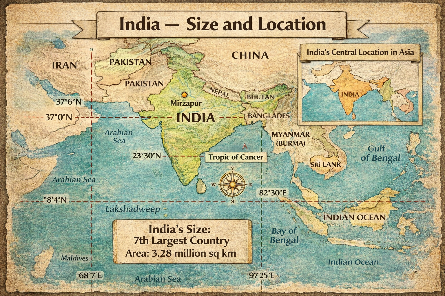
- India lies in the Northern Hemisphere.
- Latitudinal extent: 8°4′N to 37°6′N.
- Longitudinal extent: 68°7′E to 97°25′E.
- The Tropic of Cancer (23°30′N) divides India into tropical and subtropical parts.
- Indian Standard Time is based on 82°30′E longitude.
- India is the 7th largest country in the world.
- India has land boundaries with 7 countries.
- The Indian Ocean has helped India develop trade and cultural contacts.
- India’s central location in Asia is strategically important.
- The Standard Meridian passes near Mirzapur (UP).
Detailed Summary (900–1200 words)
The chapter India — Size and Location is a foundational topic in Class 9 Geography that explains where India is situated on the globe and why its position is important. India’s geographical location has greatly influenced its climate, trade, cultural contacts, and strategic importance.
India’s Latitudinal and Longitudinal Extent
India extends between 8°4′ North latitude and 37°6′ North latitude. This means the country lies entirely in the Northern Hemisphere. Longitudinally, India stretches from 68°7′ East to 97°25′ East. These coordinates are crucial in understanding India — Size and Location because they determine India’s climate, vegetation, and time zone.
The Tropic of Cancer (23°30′N) passes almost through the middle of the country. Because of this, India — Size and Location places the southern part in the tropical zone and the northern part in the subtropical zone. This division explains the diversity in India’s climate and natural vegetation.
India and the Indian Standard Time
India has a wide longitudinal extent of about 30 degrees. If every region followed its local time, there would be confusion. Therefore, the government adopted a standard time based on 82°30′ East longitude, which passes near Mirzapur in Uttar Pradesh.
This uniform time is called Indian Standard Time (IST). Understanding this concept is an important part of India — Size and Location, especially for exam questions related to time difference.
Size of India
India is the seventh largest country in the world with an area of about 3.28 million square kilometres. The large size contributes to physical diversity such as mountains, plains, deserts, plateaus, and coastal regions.
The chapter India — Size and Location emphasizes that India’s vast size supports:
- Diverse climate
- Rich biodiversity
- Varied agriculture
- Cultural diversity
Because of its large population and size, India holds an important position in South Asia.
India’s Centrality in Asia
One of the most significant aspects of India — Size and Location is its central position in the Asian continent. India lies between East and West Asia, which historically made it a meeting point of different cultures.
For centuries, traders, travellers, and invaders came to India through land routes such as the Silk Route and through sea routes across the Indian Ocean. This centrality helped India develop:
- Cultural exchanges
- Trade relations
- Spread of ideas and religions
Thus, India — Size and Location has greatly influenced India’s historical development.
India and Its Neighbours
India shares land boundaries with several countries. In the northwest, it borders Pakistan and Afghanistan. In the north, it shares borders with China (Tibet region), Nepal, and Bhutan. In the east, India is bordered by Bangladesh and Myanmar.
Across the seas, India’s neighbours include Sri Lanka (separated by the Palk Strait) and the Maldives in the Arabian Sea.
Knowledge of neighbouring countries is an important part of India — Size and Location and is frequently asked in map-based questions.
India and the Indian Ocean
India’s location near the Indian Ocean has been extremely advantageous. The ocean routes connected India with Africa, Europe, and Southeast Asia. Because of this, India developed strong maritime trade relations.
The name “Indian Ocean” itself reflects India’s importance. The chapter India — Size and Location highlights that India’s peninsular shape helped it maintain contact with distant regions.
Through these sea routes:
- Indian spices reached Europe
- Indian culture spread to Southeast Asia
- Trade flourished for centuries
Thus, India’s location promoted economic and cultural growth.
Importance of India’s Location
The strategic importance of India — Size and Location can be understood through several points:
1. Climatic Diversity
India’s latitudinal extent results in varied climates from tropical to subtropical.
2. Cultural Contacts
India’s central position in Asia facilitated cultural exchange with other civilizations.
3. Trade Advantages
Proximity to major sea routes helped India become a trading hub.
4. Strategic Importance
India’s location in South Asia gives it geopolitical significance.
5. Natural Diversity
The large size supports diverse landforms and ecosystems.
Why This Chapter Matters for Exams
Students must carefully study India — Size and Location because it forms the base for later geography chapters. Questions often appear on:
- Latitudes and longitudes
- Tropic of Cancer
- Indian Standard Time
- Neighbouring countries
- Map work
A clear understanding of India — Size and Location helps in scoring high marks in Geography.
Flowchart / Mind Map (Text-Based)
India — Size and Location
→ Latitudinal Extent (8°4′N – 37°6′N)
→ Longitudinal Extent (68°7′E – 97°25′E)
→ Tropic of Cancer divides India
→ Indian Standard Time (82°30′E)
→ Size: 7th largest country
→ Central location in Asia
→ Neighbouring countries
→ Importance for trade and culture
→ Strategic significance
Important Keywords with Meanings
Latitude: Angular distance north or south of the Equator.
Longitude: Angular distance east or west of the Prime Meridian.
Tropic of Cancer: Latitude at 23°30′N dividing tropical and subtropical India.
Indian Standard Time (IST): Uniform time based on 82°30′E longitude.
Standard Meridian: Longitude selected as the time reference.
Subcontinent: A large landmass forming a distinct part of a continent.
Peninsula: Land surrounded by water on three sides.
Central Location: Position that connects different regions easily.
Important Questions & Answers
Short Answer Questions
Q1. Why is the Tropic of Cancer important for India?
Answer: It divides India into tropical and subtropical regions, influencing climate and vegetation patterns.
Q2. Why does India have only one standard time?
Answer: To maintain uniformity across the country despite its wide longitudinal extent.
Q3. Name India’s eastern neighbours.
Answer: Bangladesh and Myanmar.
Q4. What is India’s rank in the world by area?
Answer: Seventh largest country.
Long Answer Questions
Q5. Explain the significance of India’s central location in Asia.
Answer:
India’s central location in Asia has played a crucial role in its historical and economic development. It acted as a bridge between East and West. Ancient trade routes passed through India, enabling exchange of goods, ideas, and culture. Sea routes through the Indian Ocean connected India with Africa and Europe. Because of this location, Indian culture spread to Southeast Asia. Even today, India’s position gives it strategic and economic importance in global trade and geopolitics. Thus, the centrality explained in India — Size and Location highlights India’s long-standing global connections.
Q6. Describe the latitudinal and longitudinal extent of India and their significance.
Answer:
India lies between 8°4′N and 37°6′N latitudes and 68°7′E and 97°25′E longitudes. The Tropic of Cancer passes almost through the middle of the country. This extent places India mostly in the tropical region but partly in the subtropical zone. As a result, India experiences diverse climatic conditions and vegetation types. The wide longitudinal extent made it necessary to adopt Indian Standard Time based on 82°30′E. Thus, the coordinates discussed in India — Size and Location explain India’s physical and climatic diversity.
20 MCQs with Answers
- India lies in the ______ Hemisphere.
A. Southern
B. Northern
C. Western
D. Eastern
Answer: B - The Tropic of Cancer is located at:
A. 0°
B. 23°30′N
C. 66°30′N
D. 90°N
Answer: B - India is the ______ largest country in the world.
A. Fifth
B. Sixth
C. Seventh
D. Eighth
Answer: C - IST is based on:
A. 68°7′E
B. 82°30′E
C. 97°25′E
D. 23°30′N
Answer: B - The Standard Meridian passes near:
A. Delhi
B. Mirzapur
C. Mumbai
D. Chennai
Answer: B - India shares land boundaries with how many countries?
A. 5
B. 6
C. 7
D. 8
Answer: C - Which water body lies to the south of India?
A. Arabian Sea
B. Bay of Bengal
C. Indian Ocean
D. Pacific Ocean
Answer: C - India’s southern neighbour across sea is:
A. Nepal
B. Sri Lanka
C. Bhutan
D. China
Answer: B - The longitudinal extent of India is about:
A. 10°
B. 20°
C. 30°
D. 40°
Answer: C - The Tropic of Cancer divides India into:
A. East and West
B. North and South
C. Tropical and Subtropical
D. Plains and Plateau
Answer: C
(Continue practicing these MCQs for strong exam preparation.)
Exam Tips / Value-Based Questions
Exam Tips
- Always remember the exact latitudes and longitudes.
- Practice map work regularly.
- Revise neighbouring countries carefully.
- Learn the importance of the Tropic of Cancer.
- Understand why IST is necessary.
Value-Based Question
Q. How does India’s location promote cultural unity?
Answer: India’s central location encouraged interaction with different cultures, promoting tolerance, diversity, and cultural exchange—values important for national unity.
Conclusion (SEO Friendly)
The chapter India — Size and Location is fundamental for understanding India’s geography. It explains how India’s position, size, and physical extent influence climate, culture, and trade. A strong grasp of India — Size and Location helps students perform well in exams and builds a base for advanced geography topics. Regular revision of notes, keywords, and MCQs from India — Size and Location will ensure excellent results in Class 9 Geography.
Here is a Class 9 History – Forest Society and Colonialism
80 Marks Question Paper (With Internal Choice)
📝 Class 9 SST – Forest Society and Colonialism
Time: 3 Hours
Maximum Marks: 80
Section A – Very Short Answer (1 × 10 = 10 marks)
Q1. Who were the shifting cultivators?
Q2. Name the German scientist who advised the British on forest management.
Q3. What is scientific forestry?
Q4. Write one reason why the British needed timber from forests.
Q5. What was the Imperial Forest Research Institute?
Q6. What is meant by reserved forests?
Q7. Who were the Kalangs of Java?
Q8. What was taungya cultivation?
Q9. Name the colonial power that ruled Indonesia.
Q10. Write one effect of forest laws on tribal people.
Section B – Short Answer (3 × 8 = 24 marks)
Q11. Why were forests important for the British? Explain any three reasons.
OR
Explain the role of forests in the pre-colonial period.
Q12. Describe the features of scientific forestry. (Any three points)
OR
Why did villagers resist the new forest laws?
Q13. What problems did shifting cultivators face under colonial rule?
OR
Explain the impact of forest laws on pastoralists.
Q14. Who were the Bastar rebels? Why did they revolt? (Any three points)
OR
Explain the role of forest communities in the Bastar rebellion.
Q15. How did the Dutch control forests in Java?
OR
What was the Blandongdiensten system?
Q16. Explain the term “deforestation” and give three causes.
OR
Why did the colonial government encourage plantation crops?
Section C – Long Answer (5 × 6 = 30 marks)
Q17. Explain the changes brought in Indian forests during British rule.
(Write any five points)
OR
Describe how forest laws affected the lives of forest dwellers.
Q18. Discuss the Bastar rebellion of 1910 in detail.
(Causes, events, and results)
OR
Explain how the colonial state used scientific forestry to increase revenue.
Q19. Compare forest management in India and Java under colonial rule.
OR
Explain the impact of commercial forestry on environment and people.
Q20. Describe the lives of forest communities before and after colonial rule.
OR
Explain why the British banned shifting cultivation.
Q21. “Forest laws created conflicts between the government and the people.” Justify the statement.
OR
Explain the role of forests in industrial development during colonial rule.
Section D – Case Study / Source-Based (6 marks)
Read the passage carefully and answer the questions:
The colonial government thought that shifting cultivation was harmful for forests. They believed it made it hard to calculate taxes and control land.
(i) Why did the British dislike shifting cultivation? (2)
(ii) How did this policy affect forest communities? (2)
(iii) Do you think the policy was justified? Give reason. (2)
Section E – Map/Visual Based (10 marks)
Part A – Map Work (5 marks)
On the outline map of India, mark:
- Bastar
- Dehradun
- One major forest region of Central India
- Region of teak forests
- Region of sal forests
Part B – Picture-Based Question (5 marks)
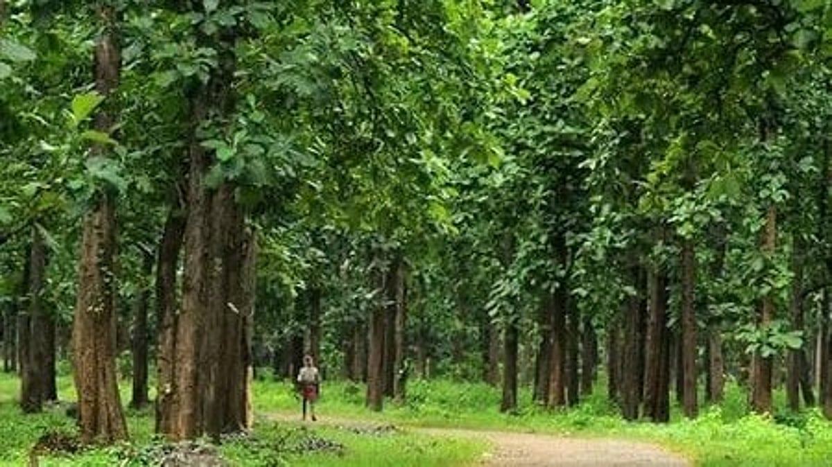

Observe the picture and answer:
(i) What type of forestry is shown in the image? (1)
(ii) Name one tree commonly planted in such forests. (1)
(iii) Give one disadvantage of this system. (1)
(iv) Who benefited most from this policy? (2)
✅ Paper ready for school exam
If you want next:
- ✔️ Solved answers
- ✔️ Extra tough paper
- ✔️ Competency-based worksheet
- ✔️ Assertion–Reason set
Just say 👍
Below is the same 80-Marks Question Paper rewritten with detailed long answers (exam-ready for Class 9).
📝 Class 9 History – Forest Society and Colonialism
✅ Solved Question Paper (Long Answers)
Time: 3 Hours
Maximum Marks: 80
✅ Section A – Very Short Answers (1 × 10 = 10)
Q1. Who were the shifting cultivators?
Ans. Shifting cultivators were forest dwellers who cleared small patches of forest, burned the vegetation, and cultivated crops for a few years before moving to another area to allow the forest to regenerate.
Q2. Name the German scientist who advised the British on forest management.
Ans. Dietrich Brandis advised the British on forest management.
Q3. What is scientific forestry?
Ans. Scientific forestry is a system of planned forest management in which trees are cut and replanted in a systematic way to ensure a regular supply of timber.
Q4. Write one reason why the British needed timber from forests.
Ans. The British needed timber mainly for building railway sleepers and ships.
Q5. What was the Imperial Forest Research Institute?
Ans. It was an institute set up at Dehradun to train forest officers and conduct research on forest management.
Q6. What is meant by reserved forests?
Ans. Reserved forests were those forests that were completely under government control and where local people’s rights were severely restricted.
Q7. Who were the Kalangs of Java?
Ans. The Kalangs were a skilled forest community in Java known for their expertise in cutting and transporting timber.
Q8. What was taungya cultivation?
Ans. Taungya cultivation was a system in which villagers were allowed to cultivate crops between forest plantations while they helped plant and protect trees.
Q9. Name the colonial power that ruled Indonesia.
Ans. The Dutch ruled Indonesia.
Q10. Write one effect of forest laws on tribal people.
Ans. Forest laws deprived tribal people of their traditional rights to use forest resources for livelihood.
✅ Section B – Short Answers (3 × 8 = 24)
Q11. Why were forests important for the British? Explain any three reasons.
Ans.
Forests were extremely important for the British colonial government due to economic and strategic reasons.
1. Timber for Railways
With the rapid expansion of railways in India after 1850, the British needed huge quantities of wooden sleepers to support railway tracks. Forests provided the required timber, especially teak and sal wood.
2. Shipbuilding
The British navy required strong and durable timber for building ships. Indian forests were rich in high-quality wood suitable for this purpose.
3. Revenue Generation
Forests were seen as a major source of income. By controlling forests and selling timber commercially, the colonial government earned large revenues.
4. Plantation Expansion
Forests were cleared to make space for tea, coffee, and rubber plantations which were profitable export crops.
Conclusion:
Thus, forests became a valuable economic resource for the British, leading to strict forest laws and exploitation.
Q12. Describe the features of scientific forestry.
Ans.
Scientific forestry was introduced by the British to regulate and maximize timber production. Its main features were:
1. Planned Cutting of Trees
Forests were divided into blocks. Trees in one block were cut each year while new trees were planted, ensuring continuous supply.
2. Monoculture Plantations
Instead of natural forests with diverse species, the British planted only commercially valuable trees like teak or sal.
3. Government Control
Forests were placed under strict government supervision. Forest officers controlled access and use.
4. Restriction on Local Rights
Traditional rights of villagers—such as grazing, collecting firewood, and shifting cultivation—were curtailed.
5. Emphasis on Commercial Value
The focus was not on ecological balance but on maximizing timber revenue.
Conclusion:
Scientific forestry increased timber supply but damaged biodiversity and harmed forest communities.
Q13. What problems did shifting cultivators face under colonial rule?
Ans.
Shifting cultivators faced severe hardships under British rule.
1. Ban on Shifting Cultivation
The British considered shifting cultivation harmful and banned it in many areas, destroying the traditional livelihood of tribal communities.
2. Loss of Land Rights
Forests were declared reserved or protected, and cultivators lost access to lands they had used for generations.
3. Forced Settlements
Many shifting cultivators were forced to settle permanently, which did not suit their traditional agricultural methods.
4. Poverty and Hardship
Without access to forest land, many tribal families fell into poverty and were forced to work as labourers.
5. Harassment by Forest Officials
Forest guards often punished people for entering forests or collecting forest produce.
Conclusion:
Colonial forest policies severely disrupted the life and culture of shifting cultivators.
✅ Section C – Long Answers (5 × 6 = 30)
Q17. Explain the changes brought in Indian forests during British rule.
Ans.
British rule brought major transformations in Indian forests.
1. Introduction of Forest Laws
The Forest Acts of 1865, 1878, and 1927 gave the government complete control over forests. Many forests were declared reserved.
2. Beginning of Scientific Forestry
Natural forests were replaced with planned plantations of commercially valuable trees like teak and sal.
3. Restriction on Local Communities
Traditional rights of tribal people were curtailed. Activities like grazing, hunting, and collecting forest produce were limited or banned.
4. Commercial Exploitation
Forests were exploited for railway sleepers, shipbuilding, and plantations. Profit became the main objective.
5. Rise of Forest Bureaucracy
A new department of forest officers and guards was created to enforce forest laws.
6. Increase in Deforestation
Large areas of forest were cleared for agriculture, railways, and plantations.
Conclusion:
British policies transformed forests from community resources into state-controlled commercial assets.
Q18. Discuss the Bastar rebellion of 1910 in detail.
Ans.
The Bastar rebellion of 1910 was an important tribal uprising against colonial forest policies.
Causes
1. Forest Reservation
The British declared large parts of Bastar forests as reserved, restricting tribal access.
2. Loss of Traditional Rights
Tribals were no longer allowed to collect forest produce, hunt, or practice shifting cultivation freely.
3. Forced Labour and Taxes
People were forced to provide free labour and pay various taxes.
4. Disrespect of Tribal Culture
Colonial policies ignored traditional customs and local authority.
Events
- Villagers attacked forest offices and police stations.
- Forest guards and officials were targeted.
- The rebellion spread rapidly across Bastar.
Results
1. Brutal Suppression
The British used military force to crush the revolt.
2. Policy Changes
Some forest restrictions were later relaxed to calm the people.
3. Rise of Tribal Resistance
The rebellion became a symbol of tribal protest against colonial exploitation.
Conclusion:
The Bastar rebellion showed the deep resentment of forest communities against British forest policies.
✅ Section D – Case Study (6 marks)
(i) Why did the British dislike shifting cultivation?
Ans. The British disliked shifting cultivation because it made forests look unproductive, made tax collection difficult, and interfered with planned timber production.
(ii) How did this policy affect forest communities?
Ans. It destroyed their traditional livelihood, forced them into poverty, and restricted their access to forest resources.
(iii) Do you think the policy was justified? Give reason.
Ans. No, it was not justified because it ignored traditional ecological knowledge and harmed the survival of tribal communities while mainly serving colonial economic interests.
✅ Section E – Picture-Based Answer
(i) Scientific forestry
(ii) Teak
(iii) It reduces biodiversity
(iv) The British colonial government and timber merchants
✅ Your long-answer solved paper is ready.
If you want:
- 🔥 Extra-hard MCQs
- 📊 Competency worksheet
- 🧠 Assertion–Reason set
- 📄 Printable PDF
Just say the word 👍
Class 9 History – Forest Society and Colonialism
50 MCQs with Answers (Exam-Oriented)
MCQs (1–10)
Q1. The British were interested in Indian forests mainly for:
A. Wildlife protection
B. Timber supply
C. Tourism
D. Medicinal plants
Ans. B. Timber supply
Q2. Who was the first Inspector General of Forests in India?
A. Lord Curzon
B. Dietrich Brandis
C. Warren Hastings
D. Cornwallis
Ans. B. Dietrich Brandis
Q3. Scientific forestry aimed at:
A. Preserving wildlife only
B. Growing only commercial trees
C. Encouraging tribal rights
D. Increasing biodiversity
Ans. B. Growing only commercial trees
Q4. Which of the following trees was most preferred by the British?
A. Neem
B. Banyan
C. Teak
D. Mango
Ans. C. Teak
Q5. The Forest Act that gave the government complete control was passed in:
A. 1857
B. 1865
C. 1878
D. 1919
Ans. C. 1878
Q6. Shifting cultivation is also known as:
A. Plantation farming
B. Taungya
C. Jhum cultivation
D. Terrace farming
Ans. C. Jhum cultivation
Q7. Reserved forests were:
A. Open to all
B. Controlled by villagers
C. Under strict government control
D. Used only for grazing
Ans. C. Under strict government control
Q8. The Imperial Forest Research Institute was set up at:
A. Delhi
B. Kolkata
C. Dehradun
D. Mumbai
Ans. C. Dehradun
Q9. Which colonial power ruled Java?
A. British
B. French
C. Dutch
D. Portuguese
Ans. C. Dutch
Q10. The Kalangs of Java were:
A. Farmers
B. Forest labourers and woodcutters
C. Traders
D. Soldiers
Ans. B. Forest labourers and woodcutters
MCQs (11–20)
Q11. Taungya cultivation was started to:
A. Help wildlife
B. Promote tribal festivals
C. Combine forestry with agriculture
D. Increase rainfall
Ans. C. Combine forestry with agriculture
Q12. Which group was most affected by forest laws?
A. Industrialists
B. Tribal communities
C. Urban traders
D. Foreign merchants
Ans. B. Tribal communities
Q13. Forest guards were appointed to:
A. Help villagers
B. Enforce forest laws
C. Teach agriculture
D. Collect rainfall data
Ans. B. Enforce forest laws
Q14. The Bastar rebellion took place in:
A. 1857
B. 1910
C. 1920
D. 1930
Ans. B. 1910
Q15. Which activity was restricted in reserved forests?
A. Railway construction
B. Grazing cattle
C. Timber cutting by British
D. Scientific forestry
Ans. B. Grazing cattle
Q16. Scientific forestry replaced natural forests with:
A. Mixed forests
B. Single-species plantations
C. Grasslands
D. Wetlands
Ans. B. Single-species plantations
Q17. The main aim of colonial forest policy was:
A. Environmental protection
B. Tribal welfare
C. Revenue and timber
D. Tourism development
Ans. C. Revenue and timber
Q18. Which act classified forests into reserved, protected and village forests?
A. Forest Act 1865
B. Forest Act 1878
C. Forest Act 1927
D. Both B and C
Ans. D. Both B and C
Q19. Shifting cultivation was banned because the British thought it:
A. Increased soil fertility
B. Damaged valuable timber forests
C. Helped villagers
D. Improved biodiversity
Ans. B. Damaged valuable timber forests
Q20. Which forest product was commonly collected by forest dwellers?
A. Coal
B. Honey and firewood
C. Petroleum
D. Iron
Ans. B. Honey and firewood
MCQs (21–30)
Q21. Forest villages were created to:
A. Promote tourism
B. Provide cheap labour for forests
C. Build cities
D. Encourage trade
Ans. B. Provide cheap labour for forests
Q22. Colonial rulers considered forests as:
A. Community property
B. Wasteland to be improved
C. Sacred groves
D. Wildlife parks
Ans. B. Wasteland to be improved
Q23. The Dutch introduced forest laws in:
A. India
B. Java
C. China
D. Japan
Ans. B. Java
Q24. Which of the following best describes monoculture?
A. Growing many crops
B. Growing one type of tree
C. Natural forest growth
D. Mixed farming
Ans. B. Growing one type of tree
Q25. Which community resisted forest laws in Bastar?
A. Tribal groups
B. Zamindars
C. British officers
D. Traders
Ans. A. Tribal groups
Q26. The British promoted plantations mainly for:
A. Local consumption
B. Export profits
C. Wildlife protection
D. Soil conservation
Ans. B. Export profits
Q27. Which crop was commonly grown in plantations?
A. Wheat
B. Tea
C. Bajra
D. Jowar
Ans. B. Tea
Q28. Forest laws turned many forest dwellers into:
A. Landowners
B. Labourers
C. Kings
D. Traders
Ans. B. Labourers
Q29. Which practice involves burning forest patches for farming?
A. Terrace farming
B. Jhum cultivation
C. Irrigation farming
D. Plantation farming
Ans. B. Jhum cultivation
Q30. The main criticism of scientific forestry was that it:
A. Increased biodiversity
B. Ignored local needs
C. Reduced timber
D. Encouraged wildlife
Ans. B. Ignored local needs
MCQs (31–40)
Q31. Which region saw the Bastar rebellion?
A. Assam
B. Chhattisgarh region
C. Punjab
D. Rajasthan
Ans. B. Chhattisgarh region
Q32. The colonial state expanded railways mainly to:
A. Help villagers
B. Transport timber and goods
C. Promote tourism
D. Reduce trade
Ans. B. Transport timber and goods
Q33. Village forests were meant for:
A. Exclusive government use
B. Community use with some rights
C. Wildlife only
D. Military camps
Ans. B. Community use with some rights
Q34. Which European country influenced scientific forestry in India?
A. Germany
B. Spain
C. Italy
D. Russia
Ans. A. Germany
Q35. Forest officials viewed shifting cultivation as:
A. Useful
B. Scientific
C. Primitive and wasteful
D. Profitable
Ans. C. Primitive and wasteful
Q36. Which was a major forest product used by villagers?
A. Plastic
B. Resin and gum
C. Steel
D. Cement
Ans. B. Resin and gum
Q37. Taungya system benefited the government because it:
A. Reduced labour costs
B. Increased rainfall
C. Promoted wildlife
D. Stopped farming
Ans. A. Reduced labour costs
Q38. Which group had traditional rights over forests before British rule?
A. Tribal communities
B. British merchants
C. Railway companies
D. European settlers
Ans. A. Tribal communities
Q39. The spread of railways increased demand for:
A. Cotton
B. Timber
C. Silk
D. Spices
Ans. B. Timber
Q40. The Bastar revolt showed:
A. Tribal cooperation with British
B. Tribal resistance to forest policies
C. Industrial growth
D. Urban development
Ans. B. Tribal resistance to forest policies
MCQs (41–50)
Q41. Which activity continued secretly despite forest laws?
A. Mining
B. Shifting cultivation
C. Shipbuilding
D. Banking
Ans. B. Shifting cultivation
Q42. Forest Acts mainly served the interests of:
A. Tribal people
B. Colonial government
C. Farmers
D. Village councils
Ans. B. Colonial government
Q43. The term ‘deforestation’ means:
A. Planting trees
B. Cutting down forests
C. Protecting wildlife
D. Irrigating land
Ans. B. Cutting down forests
Q44. Which institution trained forest officers?
A. IIT
B. Imperial Forest Research Institute
C. Calcutta University
D. Survey of India
Ans. B. Imperial Forest Research Institute
Q45. Forest communities depended on forests mainly for:
A. Livelihood
B. Luxury
C. Tourism
D. Banking
Ans. A. Livelihood
Q46. The Dutch in Java used forests mainly for:
A. Wildlife parks
B. Timber extraction
C. Tourism
D. Education
Ans. B. Timber extraction
Q47. Scientific forestry encouraged:
A. Mixed forests
B. Natural growth
C. Planned plantations
D. Tribal ownership
Ans. C. Planned plantations
Q48. Which was NOT a forest classification under the British?
A. Reserved
B. Protected
C. Village
D. Private royal forests
Ans. D. Private royal forests
Q49. Forest laws made life difficult mainly for:
A. Industrialists
B. Forest dwellers
C. British officers
D. Traders
Ans. B. Forest dwellers
Q50. The overall impact of colonial forest policy was:
A. Complete forest protection
B. Increased tribal welfare
C. Commercial exploitation of forests
D. End of timber trade
Ans. C. Commercial exploitation of forests
✅ Your 50 MCQs set is ready.
If you want next:
- Assertion–Reason MCQs
- Case-based MCQs
- HOTS questions
- Printable worksheet
Just tell me.
India — Size and Location Class 9
Case-Based Questions (50) with Answers
Chapter Focus: India — Size and Location (NCERT Class 9 Geography)
Instructions: Read each case carefully and answer the questions that follow. These are competency-based and exam-oriented.
Case Study 1: India’s Latitudinal and Longitudinal Extent
India lies entirely in the Northern Hemisphere. The Tropic of Cancer (23°30’N) passes almost through the middle of the country. The mainland of India extends between 8°4’N and 37°6’N latitudes and from 68°7’E to 97°25’E longitudes.
Questions
1. In which hemisphere is India located?
Answer: India is located in the Northern Hemisphere.
2. Which important latitude divides India into two parts?
Answer: The Tropic of Cancer (23°30’N).
3. What is the latitudinal extent of mainland India?
Answer: 8°4’N to 37°6’N.
4. What is the longitudinal extent of India?
Answer: 68°7’E to 97°25’E.
5. Name the imaginary line passing almost through the middle of India.
Answer: Tropic of Cancer.
Case Study 2: India’s Central Location in Asia
India occupies an important central position in South Asia. Its location has helped India develop close contact with the rest of Asia, Africa, and Europe through land routes and sea routes since ancient times.
Questions
6. Why is India’s location considered central in Asia?
Answer: Because it lies at the head of the Indian Ocean and connects East and West through land and sea routes.
7. How did India’s location help in ancient times?
Answer: It helped in trade, cultural contacts, and exchange of ideas.
8. Which ocean lies to the south of India?
Answer: The Indian Ocean.
9. Name one advantage of India’s central location.
Answer: Easy contact with other countries for trade and cultural exchange.
10. Through which routes did India maintain contacts historically?
Answer: Land routes and sea routes.
Case Study 3: India and the Indian Standard Time (IST)
India has a longitudinal extent of about 30 degrees. This creates a time difference of nearly two hours between the eastern and western parts. To maintain uniform time, India follows Indian Standard Time based on 82°30’E longitude.
Questions
11. Why was Indian Standard Time adopted?
Answer: To maintain uniform time across the country.
12. Which longitude is chosen for IST?
Answer: 82°30’E longitude.
13. How much time difference exists between eastern and western India approximately?
Answer: About two hours.
14. What would happen without a standard time?
Answer: Different regions would have different local times causing confusion.
15. IST passes near which Indian city/state (commonly mentioned)?
Answer: Near Mirzapur in Uttar Pradesh.
Case Study 4: India’s Size and Physical Presence
India is the seventh-largest country in the world. It has a total area of about 3.28 million square kilometres. Its large size contributes to diversity in climate, vegetation, and culture.
Questions
16. What is India’s rank in the world by area?
Answer: Seventh largest.
17. What is the total area of India?
Answer: About 3.28 million square kilometres.
18. Name one advantage of India’s large size.
Answer: Diversity in climate, vegetation, and culture.
19. Large size of India leads to diversity in which three aspects?
Answer: Climate, natural vegetation, and culture.
20. Why is India called a subcontinent?
Answer: Because of its large size, varied relief, and distinct geographical identity.
Case Study 5: India’s Neighbours
India shares its land boundaries with several countries. Pakistan and Afghanistan lie to the northwest, China, Nepal and Bhutan to the north, and Bangladesh and Myanmar to the east. Sri Lanka is separated by sea.
Questions
21. Which country lies to the northwest of India?
Answer: Pakistan and Afghanistan.
22. Name India’s northern neighbours.
Answer: China, Nepal, and Bhutan.
23. Which countries lie to the east of India?
Answer: Bangladesh and Myanmar.
24. Which country is separated from India by sea in the south?
Answer: Sri Lanka.
25. Through which water body is Sri Lanka separated from India?
Answer: Palk Strait.
Case Study 6: Importance of the Indian Ocean
The Indian Ocean is named after India. India’s location at the head of the Indian Ocean helped it establish maritime trade links with West Asia, East Africa, and Southeast Asia.
Questions
26. Which ocean is named after India?
Answer: Indian Ocean.
27. Why was India able to develop strong maritime contacts?
Answer: Because of its central location at the head of the Indian Ocean.
28. Name one region with which India traded through sea routes.
Answer: East Africa (any one: West Asia / Southeast Asia).
29. What type of routes connected India overseas?
Answer: Sea routes.
30. India’s southern boundary is formed by which ocean?
Answer: Indian Ocean.
Case Study 7: India’s Time and Daylight
Due to India’s east-west extent, the sun rises earlier in the eastern states than in the western states. However, the whole country follows one standard time.
Questions
31. Where does the sun rise earlier in India — east or west?
Answer: East.
32. Why is there a difference in sunrise time?
Answer: Because of India’s wide longitudinal extent.
33. What system solves this time difference?
Answer: Indian Standard Time.
34. Approximately how many degrees of longitude does India cover?
Answer: About 30 degrees.
35. What would be confusing without IST?
Answer: Daily schedules and timekeeping.
Case Study 8: India’s Strategic Location
India’s geographical position helped it become a centre of trade and cultural exchange. Traders, travelers, and invaders used routes passing through the Indian subcontinent.
Questions
36. What made India a centre of trade historically?
Answer: Its strategic central location.
37. Who used routes through India in the past?
Answer: Traders, travelers, and invaders.
38. Name one benefit of India’s strategic location.
Answer: Cultural exchange with other regions.
39. India connects which two major parts of Asia?
Answer: East Asia and West Asia.
40. What type of exchanges happened due to India’s location?
Answer: Trade and cultural exchanges.
Case Study 9: Tropic of Cancer and Climate
The Tropic of Cancer divides India into tropical and subtropical regions. Areas south of it have tropical climate, while areas north experience subtropical conditions.
Questions
41. What climatic zones does the Tropic of Cancer divide?
Answer: Tropical and subtropical zones.
42. Which region of India is tropical?
Answer: Areas south of the Tropic of Cancer.
43. Areas north of the Tropic of Cancer fall in which zone?
Answer: Subtropical zone.
44. Why is the Tropic of Cancer important?
Answer: It influences India’s climate pattern.
45. Write the latitude of the Tropic of Cancer.
Answer: 23°30’N.
Case Study 10: India’s Physical and Cultural Diversity
Because of its vast size and central location, India developed great physical and cultural diversity. Different climates and contacts with many regions enriched Indian civilisation.
Questions
46. What two major factors created diversity in India?
Answer: Large size and central location.
47. Name one type of diversity seen in India.
Answer: Cultural diversity (also acceptable: climatic/physical).
48. How did foreign contacts influence India?
Answer: They enriched Indian culture and civilisation.
49. India’s diversity is mainly due to its size and ______.
Answer: Location.
50. Why is India geographically significant in the world?
Answer: Because of its central location, large size, and strategic position in South Asia.
Exam Tip: Practice these case-based questions of India — Size and Location to strengthen competency-based preparation for Class 9 Geography exams.
India — Size and Location
Additional Case-Based Questions (Set 2) with Answers
Chapter Focus: India — Size and Location (Class 9 Geography)
Instructions: Read each passage carefully and answer the questions that follow. These are high-level, exam-oriented case-based questions.
Case Study 11: India and the Tropic of Cancer
The Tropic of Cancer (23°30’N) passes almost through the middle of India. This imaginary line divides the country into two distinct climatic regions. Areas to the south experience tropical climate, while areas to the north have subtropical conditions. This division influences vegetation, agriculture, and seasons in different parts of India.
Questions
1. What is the latitude of the Tropic of Cancer?
Answer: 23°30’N.
2. What does the Tropic of Cancer divide in India?
Answer: It divides India into tropical and subtropical climatic regions.
3. Which part of India has a tropical climate?
Answer: The southern part of India (south of the Tropic of Cancer).
4. Name one aspect influenced by this division.
Answer: Agriculture (also acceptable: vegetation/seasons/climate).
5. Why is the Tropic of Cancer important for India?
Answer: Because it determines major climatic patterns across the country.
Case Study 12: India’s Land Routes
In ancient times, India maintained strong contacts with Central Asia, West Asia, and Southeast Asia through land routes. These routes helped in the exchange of goods, ideas, religions, and culture. Many invaders and traders also entered India through these routes.
Questions
6. With which regions did India maintain land contacts?
Answer: Central Asia, West Asia, and Southeast Asia.
7. What exchanges took place through land routes?
Answer: Goods, ideas, religions, and culture.
8. Who commonly entered India through these routes?
Answer: Traders and invaders.
9. Name one benefit of these land contacts.
Answer: Cultural exchange (also acceptable: trade development).
10. What do these contacts show about India’s location?
Answer: It shows that India had a strategic and accessible location.
Case Study 13: India’s Time Difference
Because India stretches about 30° in longitude, there is nearly a two-hour difference between sunrise times in the eastern and western parts of the country. To avoid confusion, a single standard time based on 82°30’E longitude was adopted.
Questions
11. What causes time difference within India?
Answer: India’s wide longitudinal extent.
12. Approximately how much time difference exists across India?
Answer: About two hours.
13. Which longitude is used for Indian Standard Time?
Answer: 82°30’E.
14. What problem would occur without IST?
Answer: Different regions would follow different local times causing confusion.
15. Why is standard time important for a country?
Answer: It ensures uniformity in daily activities, transport, and communication.
Case Study 14: India’s Neighbourhood
India shares land boundaries with several countries. Its strategic position in South Asia makes it important politically and economically. The Himalayan mountains act as a natural barrier in the north.
Questions
16. What natural feature protects India in the north?
Answer: The Himalayan mountains.
17. Why is India’s position in South Asia important?
Answer: Because it has strategic political and economic importance.
18. Name one function of the Himalayas.
Answer: They act as a natural barrier.
19. What type of boundaries does India share with neighbours?
Answer: Land boundaries (and also maritime boundaries).
20. India is part of which continent?
Answer: Asia.
Case Study 15: India and Maritime Trade
India’s long coastline and central position in the Indian Ocean helped it develop strong maritime trade links. Ancient Indian traders travelled to East Africa, Arabia, and Southeast Asia.
Questions
21. What geographical feature helped India in sea trade?
Answer: Its long coastline and central location in the Indian Ocean.
22. Name one region connected with India through sea trade.
Answer: East Africa (also acceptable: Arabia/Southeast Asia).
23. What type of routes were used in maritime trade?
Answer: Sea routes.
24. What was one major benefit of maritime contacts?
Answer: Growth of trade and cultural exchange.
25. Which ocean played a major role in India’s overseas contacts?
Answer: Indian Ocean.
Case Study 16: India’s Physical Diversity
India’s vast size leads to great physical diversity. The country has mountains, plains, plateaus, deserts, and coastal regions. This variety also influences climate and human activities.
Questions
26. What is the main reason for India’s physical diversity?
Answer: Its large geographical size.
27. Name any two physical features of India.
Answer: Mountains and plains (any two acceptable).
28. How does physical diversity affect people?
Answer: It influences climate, agriculture, and lifestyle.
29. Which type of relief is found in northern India?
Answer: Mountains (Himalayas).
30. Physical diversity leads to diversity in ______.
Answer: Climate and lifestyle.
Case Study 17: India as a Subcontinent
India is often called a subcontinent because of its large size, varied relief, and distinct geographical identity. It stands out clearly from the rest of Asia.
Questions
31. Why is India called a subcontinent?
Answer: Due to its large size and distinct geographical features.
32. Name one feature that makes India distinct.
Answer: Varied relief (mountains, plains, plateau).
33. India is part of which larger continent?
Answer: Asia.
34. What does the term subcontinent indicate?
Answer: A large landmass with distinct geographical identity.
35. Give one geographical reason for India’s uniqueness.
Answer: Presence of diverse physical features.
Case Study 18: India’s Centrality and Cultural Exchange
India’s location between East and West made it a meeting point of different cultures. Ideas such as Buddhism spread from India to other parts of Asia through trade routes.
Questions
36. Why is India called a meeting point of cultures?
Answer: Because its central location connected East and West.
37. Name one idea that spread from India.
Answer: Buddhism.
38. Through what medium did cultural exchange occur?
Answer: Trade routes.
39. India’s location promoted exchange of ______ and ______.
Answer: Goods and ideas.
40. What does this show about India’s historical importance?
Answer: India played a major role in cultural diffusion.
Case Study 19: India’s Standard Time Line
The 82°30’E longitude passes near the centre of India and is used to calculate Indian Standard Time. This ensures uniform time throughout the country despite its wide east-west spread.
Questions
41. Why was 82°30’E chosen for IST?
Answer: Because it passes near the central part of India.
42. What is the full form of IST?
Answer: Indian Standard Time.
43. IST helps maintain what across India?
Answer: Uniform time.
44. Without IST, what problem would India face?
Answer: Multiple local times and confusion.
45. IST is based on which type of lines?
Answer: Longitudes.
Case Study 20: India’s Strategic Importance
India’s location in South Asia gives it strategic importance in world trade and politics. Its proximity to major sea routes increased its global contacts.
Questions
46. Why is India strategically important?
Answer: Due to its central location in South Asia and near major sea routes.
47. India’s location benefits which two major fields?
Answer: Trade and politics.
48. What increased India’s global contacts?
Answer: Its proximity to major sea routes.
49. India lies at the head of which ocean?
Answer: Indian Ocean.
50. Give one modern importance of India’s location.
Answer: Facilitates international trade and connectivity.
Exam Tip: Practice multiple sets of case-based questions from India — Size and Location to master competency-based and CBSE pattern questions.
Leave a Reply